
Cumberland Congregational Church
Cumberland Historical Society
Succession of Secession
Role of the Church Parishes
In Ancient North Yarmouth and Yarmouth, A History: 1636-1936, William Rowe observed that “In early New England the history of the church is the history of the community.” This is particularly true for Ancient North Yarmouth. From 1730, the Church Under the Ledge in the coastal area, now Route 88 in Yarmouth, was the center of the community, providing both worship and town administration. A large structure, the Church furnished space for town meetings, kept records of births, deaths and marriages, and collected taxes for town and parish (church) business. As settlement spread to the far-flung reaches of North Yarmouth, travel to attend church and town meetings became increasingly difficult. For the inhabitants of Harpswell, this meant travelling to worship each week by boat! Understandably, they were the first town to secede from North Yarmouth. In 1750, the Settlers of Harpswell established their own separate parish, and, eight years later, incorporated as a distinct town. Freeport set off as its own town in 1789, followed by Pownal in 1808.

North Yarmouth Congregational Church ca. 1900
North Yarmouth Historical Society
Like the people in these two towns, those in the ‘back’ lots of North Yarmouth also wanted their own church and civic center close to where they lived. They worked hard to make it happen. The residents of Walnut Hill built the “Great Schoolhouse” (c. 1780 ) near the Walnut Hill Cemetery on Route 115 and also used it for worship. By 1794, the hamlet that was to become Cumberland Center established the Second Social Library of North Yarmouth and built a meetinghouse that was used for worship.
Beginning in 1793, a group of residents organized the “Second Church of North Yarmouth” which was built at the corner of what is now Routes 115 and 231. On June 26, 1794, one hundred and thirty church members petitioned the Massachusetts Legislature for the right to form their own parish, separate from The Church Under the Ledge, and this became the “North West Congregational Society of North Yarmouth.” In these early years, the Second Church services alternated between the meetinghouse in Cumberland and the one in North Yarmouth. People who lived in these areas were free to attend church in either location.
In 1806, the Massachusetts Legislature approved the separation of North Yarmouth into two geographical parishes and the back lot area of North Yarmouth and Cumberland became the Second Territorial Parish. Six months later, Walnut Hill residents formed the Third Church in North Yarmouth, which met in the meetinghouse at the corner of Routes 115 and 231, and Cumberland residents localized to the church at the Route 9/Blanchard Road intersection.

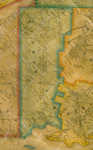
Cumberland Map
Cumberland’s Secession: 1821
This church split foreshadowed the secession of the town of Cumberland from North Yarmouth, which came about 15 years later. By 1820, Cumberland inhabitants had established their separate place of worship and now it was time to make a clean break in town administration, too. In a petition to the newly-minted Maine Legislature, 176 male residents of Cumberland who signed a petition to the Legislature that year noted that “the town business [is] done at North Yarmouth Corner…subjecting your petitioners to the necessity of extensive travel, some of them at least a distance of nine miles to attend a town meeting, and perform the ordinary duties of a citizen.” The Legislature granted Cumberland an Act of Incorporation in 1821, over the objections of many North Yarmouth residents. The border between the two towns shows how difficult it was for landowners to choose between towns! Years later, in 2007, Cumberland experienced its own separation and division when Chebeague Island was granted its independence.

Yarmouth Map
Yarmouth Takes Its Leave: 1849
The last town to secede from North Yarmouth was coastal Yarmouth. This was probably the most traumatic separation for what remained of ancient North Yarmouth. By 1849, strong ties had developed between Yarmouth village and the interior. Trees cut for lumber near Walnut Hill village were used to build ships in Yarmouth’s harbor; farms produced crops that were sold in the village and village merchants sold goods to the rural farmers. Access to ship transportation in Yarmouth was essential, as trains hadn’t yet come to the interior. The Town Hall, Masonic Lodge, North Yarmouth Academy, the militia, the town band, the fire company and the Abolitionist Society that North Yarmouth residents enjoyed now existed within the boundaries of the town that split away.

Declaration of Independence
Maine State Archives
Nonetheless, North Yarmouth remained as the surviving town, and retained legal possession of the earliest records, some of which date back to the 1600s and have tremendous historical value. Believe it or not, North Yarmouth has one of the original signed copies of the Declaration of Independence! In 1853, a new town hall was built in the geographical center of the town, between the two villages of East North Yarmouth and Walnut Hill. Today, that venerable building on Route 9 is home to the North Yarmouth Historical Society.