From One Town, Many: Ancient North Yarmouth
We are now two separate towns, but more than three hundred years ago, North Yarmouth and Cumberland, together with five of our neighboring communities, were all part of Ancient North Yarmouth. The original 1680 plantation of North Yarmouth encompassed present-day North Yarmouth, Cumberland, Yarmouth, Chebeague Island, Pownal, Freeport, Harpswell, and the Mere Point portion of Brunswick. It was one of the oldest and largest towns in the Province of Maine. Most of its settlers divided their land into lots and built along the immediate coast, particularly near the Royal River, named for William Royall, one of the earliest settlers of this area called Wescustogo.
Wilderness Origins
Long before the European settlers arrived, our region of Maine was home to members of the Abenaki tribe, who, together with the Maliseet, Passamaquoddy, Mi’kmaq and Penobscot Indians, were members of the old Wabanaki Confederacy, the traditional adversaries of the Iroquois. The name Abenaki has an Algonquian root, meaning "people from the east." Settlement patterns suggest a rather fluid arrangement for the Eastern Abenaki, who farmed the fertile plains of the Kennebec and Androscoggin Rivers, and spread out along lands west of Casco Bay in small family and tribal settlements.
English Settlers Arrive
In the mid-1630s William Royall moved to the Casco Bay region from Salem, Massachusetts, and in March 1643 had his land holdings around the river known as Wescustogo confirmed by Thomas Gorges, Deputy Governor for the Province of Maine. In later years the river came to be known as the Royal River, the name it carries today. The Royalls were one of the earliest European settlers, but others soon followed. Most were from England; and many were descendants of settlers in Massachusetts. They were drawn to North Yarmouth, where great tracts of land were still available and natural resources, such as timber and fish, were abundant. William and Phoebe Royall settled on the eastern side of the Royal River. They built a house and farmed land between the Royal (Wescustogo) and Cousins (Chusquissacke) Rivers, in what is now present-day Yarmouth and Freeport.
Wescustogo had certain advantages: a good, protected harbor and plentiful reserves for fishing and hunting. The land was filled with huge trees which the European settlers could harvest for trade with England. More settlers followed and began to farm along the coast. The settlements grew in population taking more and more land, which created tensions with the native Abenaki. In 1676, the conflict between the natives, who had been generally welcoming, and the European settlers in New England became known as King Philip’s War. As part of this conflict, all 65 colonists of North Yarmouth were driven off the land on which they had settled. Some returned within a few years to resettle, but were again driven away after a series of attacks which were part of another regional conflict in 1688, known as King William’s War. The retreat from this second conflict was so complete that settlers did not return until around 1715.
The conflicts between the natives and the European settlers continued through the years, escalating during the French and Indian War of the 1750s, when many European settlers were captured, killed, or had their homes burned. However, the settlers were persistent and eventually the Abenaki moved further inland and north towards Quebec, which allowed the settlers to regain their footing. After 1758, peace prevailed and the white settlement of North Yarmouth, at the mouth of the Royal River, grew and prospered.
Establishing Boundaries and Lots
As the area was resettled after 1715, boundaries and lots were established. In the 1720s, twenty families returned to North Yarmouth and built three garrisons for protection. In 1727, the plantation was divided and mapped indicating specific land lots and ownership. North Yarmouth’s boundary with Falmouth was reestablished and marked by a large boulder known as the “white rock”. Returning settlers, who had been driven out in the Indian Wars, were given first choice of lots. Some selected new lots or incorporated them into their old lands. Newly arriving settlers chose from what remained.
One hundred and three original proprietors (owners) purchased “home lots” of 10 acres near the coast. If they were able to improve the lots and keep them occupied for five years, they received an additional lot of 100 or 120 acres in the interior back lots, known as the “after divisions.” This land was a valuable source of timber and after the trees were harvested, the property would serve as farmland. One hundred “after divisions” were created and sixty-four people became owners.


Cumberland Center, 1857
Settlements grow into Town Villages
Settlement progressed rapidly in Ancient North Yarmouth after the American Revolution. The descendents of the original proprietors had large families, and the population grew rapidly. On its books in 1764, North Yarmouth listed 188 families living in 154 houses, for a total of 1,097 inhabitants, including 18 African Americans. By the time of the first US Census of 1790, the town’s population had almost doubled, to 1,905 persons.
Village centers began to develop where inhabitants could go to acquire goods or services—at general stores, blacksmiths, and carriage-making shops. Villages such as East North Yarmouth, Walnut Hill, and Poland’s Corner were centered around the local churches or at intersections of travel lanes, where inland roads met stagecoach routes. When railroad lines were established, in later years, villages grew where train depots were located.
Succession of Secession
Role of the Church Parishes
In Ancient North Yarmouth and Yarmouth, A History: 1636-1936, William Rowe observed that “In early New England the history of the church is the history of the community.” This is particularly true for Ancient North Yarmouth. From 1730, the Church Under the Ledge in the coastal area, now Route 88 in Yarmouth, was the center of the community, providing both worship and town administration. A large structure, the Church furnished space for town meetings, kept records of births, deaths and marriages, and collected taxes for town and parish (church) business. As settlement spread to the far-flung reaches of North Yarmouth, travel to attend church and town meetings became increasingly difficult. For the inhabitants of Harpswell, this meant travelling to worship each week by boat! Understandably, they were the first town to secede from North Yarmouth. In 1750, the Settlers of Harpswell established their own separate parish, and, eight years later, incorporated as a distinct town. Freeport set off as its own town in 1789, followed by Pownal in 1808.
Like the people in these two towns, those in the ‘back’ lots of North Yarmouth also wanted their own church and civic center close to where they lived. They worked hard to make it happen. The residents of Walnut Hill built the “Great Schoolhouse” (c. 1780 ) near the Walnut Hill Cemetery on Route 115 and also used it for worship. By 1794, the hamlet that was to become Cumberland Center established the Second Social Library of North Yarmouth and built a meetinghouse that was used for worship.
Beginning in 1793, a group of residents organized the “Second Church of North Yarmouth” which was built at the corner of what is now Routes 115 and 231. On June 26, 1794, one hundred and thirty church members petitioned the Massachusetts Legislature for the right to form their own parish, separate from The Church Under the Ledge, and this became the “North West Congregational Society of North Yarmouth.” In these early years, the Second Church services alternated between the meetinghouse in Cumberland and the one in North Yarmouth. People who lived in these areas were free to attend church in either location.
In 1806, the Massachusetts Legislature approved the separation of North Yarmouth into two geographical parishes and the back lot area of North Yarmouth and Cumberland became the Second Territorial Parish. Six months later, Walnut Hill residents formed the Third Church in North Yarmouth, which met in the meetinghouse at the corner of Routes 115 and 231, and Cumberland residents localized to the church at the Route 9/Blanchard Road intersection.
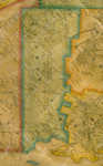
Cumberland Map
Cumberland’s Secession: 1821
This church split foreshadowed the secession of the town of Cumberland from North Yarmouth, which came about 15 years later. By 1820, Cumberland inhabitants had established their separate place of worship and now it was time to make a clean break in town administration, too. In a petition to the newly-minted Maine Legislature, 176 male residents of Cumberland who signed a petition to the Legislature that year noted that “the town business [is] done at North Yarmouth Corner…subjecting your petitioners to the necessity of extensive travel, some of them at least a distance of nine miles to attend a town meeting, and perform the ordinary duties of a citizen.” The Legislature granted Cumberland an Act of Incorporation in 1821, over the objections of many North Yarmouth residents. The border between the two towns shows how difficult it was for landowners to choose between towns! Years later, in 2007, Cumberland experienced its own separation and division when Chebeague Island was granted its independence.

Yarmouth Map
Yarmouth Takes Its Leave: 1849
The last town to secede from North Yarmouth was coastal Yarmouth. This was probably the most traumatic separation for what remained of ancient North Yarmouth. By 1849, strong ties had developed between Yarmouth village and the interior. Trees cut for lumber near Walnut Hill village were used to build ships in Yarmouth’s harbor; farms produced crops that were sold in the village and village merchants sold goods to the rural farmers. Access to ship transportation in Yarmouth was essential, as trains hadn’t yet come to the interior. The Town Hall, Masonic Lodge, North Yarmouth Academy, the militia, the town band, the fire company and the Abolitionist Society that North Yarmouth residents enjoyed now existed within the boundaries of the town that split away.
Nonetheless, North Yarmouth remained as the surviving town, and retained legal possession of the earliest records, some of which date back to the 1600s and have tremendous historical value. Believe it or not, North Yarmouth has one of the original signed copies of the Declaration of Independence! In 1853, a new town hall was built in the geographical center of the town, between the two villages of East North Yarmouth and Walnut Hill. Today, that venerable building on Route 9 is home to the North Yarmouth Historical Society.
Separate yet Similar
Agricultural Roots
By the midpoint in the 19th century, our two towns, though separate, were similar in many ways. Most importantly, we were both farming communities, from our earliest days, and remained so for most of our shared history. Our communities could only grow and prosper if supported by a good economy. Agriculture was the primary business of most residents of both towns during the 1800s and into the 1900s, and many factors affected farming such as climate, population, and advancing new methods in education.
Maine Weather: Don’t like it? Just wait a minute
Climate trends, including a “Little Ice Age,” a century-long period of volatile climate changes in the 1800s, had significant impact on agriculture in Maine. From 1765 through 1880 our climate was generally cool, interspersed with short periods of more moderate, as well as more severe, conditions. In 1816, Maine experienced the “Year Without a Summer,” a devastating year for agriculture in which snow fell in June! Throughout the 1820s the climate was mild, raising expectations among farmers and prompting the introduction of new cash crops, including such exotic ones as silkworms. Cooler temperatures returned in the early 1830s, however, along with an increase in precipitation that lasted for nearly fifty years.
The difficult climate was tough enough, but Maine farmers were also facing competition from the West, where crops were cheaper to grow and send east by railroad. The farmers who remained in Cumberland and North Yarmouth survived by diversifying crop and livestock production, developing sideline non-farming business, and manufacturing nontraditional products and crafts.
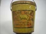
Lard Bucket
Farming Diversity
Unlike large single-crop farms of the west, our local farms produced a variety of products for both farm use and sale to markets beyond Cumberland and North Yarmouth. Many early farmers raised sheep for meat and wool; some wool was sold to the Shakers in New Gloucester or Mayall Mill in Gray. The landscape of our towns is very different today, wooded now where once sheep and cattle grazed the fields, keeping down growth and preserving wide vistas.

Merrill Bros label
In the late 1800s production of potatoes and corn and other vegetables was sufficient enough to support at least two canneries, which handled vegetables, fruits and meat. Merrill Brothers at Cumberland Junction had a capacity for 3,000 cans a day and operated from 1881 to the early 1900s. In the late 1890s Charles E. Herrick and his son Horatio operated a corn canning factory that provided seasonal employment for many local young people.
Apples were, and continue to be, an important piece of the agricultural heritage of the towns, as exemplified by the Sweetser family. In the 1830s, Samuel and Amasa Sweetser were grafting trees and developing new strains of apples. Their son Frederick was an early member of the Maine Pomological Society, and his son, Herman, was a professor of horticulture at the University of Maine at Orono. Herman’s son Dick and his wife Connie operate the Apple Barrel store on Blanchard Road in Cumberland into the 21st century.
In addition to growing food, area farmers were noted for their success with growing flowers. In the early 1890s Frank and Arno Chase had a greenhouse selling their product under the Chase Brothers name. By 1904, Cumberland had four large greenhouses boasting 28,000 feet of glass, producing flowers, primarily carnations, for the state’s wholesale trade. Howard C. Blanchard built two small greenhouses in 1914, and later constructed two larger houses with 30,000 square feet of glass. The F.D. Morrill Greenhouse on Walnut Hill Road in North Yarmouth produced carnations and snapdragons that were shipped by rail to markets in Boston and Bangor. The business ran from 1927-1959, operated successively by Fred Morrill and Arthur Dunn. The greenhouses were later sold and moved to Allen Farms in West Cumberland.
Dairy and beef cattle were also mainstays of the area’s farms. Spring Brook Farm on Greely Road, started in the early 1800s by Beza Blanchard, began commercial operations under Frank Blanchard after his service in the Civil War, and still sells milk and other dairy products. Walnut Hill Creamery, a cooperative venture founded in 1892, took advantage of the availability of local milk for butter making. Frank Hilton and later his son Kent Sr. operated Elm Farms Dairy on Ledge Road; The O' Donnell family ran North Yarmouth Dairy in the 1930s and 1940s, and the Weston and Sherman Grover families had a large dairy on Sligo Road into the 1960s. North Yarmouth’s last dairy operation, Norman and Marion Reed's Cedar Spring Farm, closed in 1977.
The agricultural heritage is still evident in area farms. Sunrise Acres Farm, begun in Cumberland in 1948, was one of the earliest farms to become certified organic, and an early pioneer of Community Supported Agriculture (CSA). In 2009, Deri Farm began a CSA at Skyline Farm, sharing its harvest of locally grown produce to participating families who live in the Greater Portland area.
Agricultural Societies
Farming families benefitted from the establishment of the Maine State Board of Agriculture in 1856 and the University of Maine in 1865. In 1867, the Patrons of Husbandry, a farmers’ organization, was founded in Washington, D.C. and through it, Grange chapters sprang up throughout the country. In North Yarmouth, Wescustogo Grange No. 27 was formed in 1874. The Grange was the place where farmers and their family members could hear about new methods of agriculture and home management. It was also an important social organization, sponsoring community events and celebrations, supporting members’ participation in local and national competitions, and advocating for excellence in farming practices. Wescustogo Grange Hall, dedicated in 1959, was built through volunteer labor and financed with bean suppers and other fundraisers. The hall was donated to North Yarmouth in 1996.
Shared History: The Civil War in North Yarmouth and Cumberland
Like so many small towns throughout the United States, Cumberland and North Yarmouth made a substantial contribution to the Union effort, and suffered significant losses that were felt for years to come. We are lucky to have the first hand accounts of what this sacrifice meant for one of the area’s prominent families, the Lawrence brothers.
Linking the Towns: Transportation and Roads
One of the most important ways our communities were connected was through our roads. Traveling was still very rough in our region throughout the 19th century. The creation and condition of our roads and their constant maintenance was worrisome for town residents and officials, since impassable inland routes kept our communities isolated especially during the winter months. Horse-drawn carriages and wagons were fundamental to our farms; they were an essential mode of transportation and would remain so into the early 1900s, until the mass production of automobiles slowly replaced them.
Steam Rail
Present day Route 9 was an important artery that joined Cumberland and North Yarmouth. Eventually, roads connected residents to the railroads, which came into the area in 1848. The rails connected both towns to markets in Portland and beyond, and made it possible for residents to sell the many goods produced on the family farm and manufactured locally. In 1900, Cumberland Junction was the center of economic activity within the town. Many trains stopped there each day to pick up local products, or to deliver dry goods, furniture and other items to local residents. The towns had two lines running through them. The earliest, the Atlantic and St. Lawrence Railroad, had opened in 1848 and later became the Grand Trunk Railway. The second rail line was merged with the Maine Central Railroad system in 1871.
Electric Rail
In 1894 the Portland and Yarmouth Electric Railway, along what is currently Route 88 in Cumberland Foreside, was chartered. The line began operating in August 1898, and soon had service every half hour from 6 am until nearly midnight. The Portland-Lewiston Interurban Railroad, chartered in 1907, began service through West Cumberland in 1914. In addition to passenger service, including monthly commuter ticket-holders, the line allowed West Cumberland’s farmers to ship their milk and farm produce daily to Portland and the Lewiston-Auburn area. Both rail lines allowed area residents to commute to the cities for work and errands, and remained in service until June 28, 1933.
Schools: A Community Value
Education of our young people has always been a focus for Cumberland and North Yarmouth, and the growth of our schools from church schools to one-room schoolhouses to community schools and finally to our joint Maine School Administrative District 51 is a story that continues to bind our two towns together. In its first town meeting in the year 1821, Cumberland appropriated $550 for education and accepted students, ranging in age from five through twenty-five, from fifteen different school districts.
Greely Institute
In 1858, one of Cumberland’s native sons left the sum of $27,500 to the town for the establishment of a school for young people aged 12 through 21. Eliphalet Greely, born on Greely Road in Cumberland in 1784, was president of Casco National Bank for 33 years and mayor of Portland for ten years. Upon his death, provisions in his will led to the building of Greely Institute, which opened on September 28, 1868 and held its first public graduation of six students in 1880. The town supported Greely Institute over the years and in 1913 it was incorporated by an act of the Maine Legislature. The town took control of Greely Institute in 1953 for the establishment of a free high school, and upon the formation of Maine School Administrative District 51 in 1966 it became Greely High School. The school district brings Cumberland and North Yarmouth, separated in 1821, together again.
The history of both towns reminds us of our common roots. We remember the tumultuous births of each town and recall their similar developments and common themes. We see also the differences, and prepare for the challenges they will face. Both are proud communities and have reason to be so. To look at our history and join together in its study, we find the roots that reach deep for both communities.
Coming Back Together
Welcoming newcomers, adapting in the face of economic difficulty, and, taking care of one’s own, are the hallmarks of Cumberland and North Yarmouth, like many small towns throughout the country. Cumberland, once part of North Yarmouth, has since surpassed its sister town in population. Both towns are two of Greater Portland’s bedroom communities, where new residents and founding families alike benefit from the nearness of Maine’s largest city while residing in a pastoral location. Each town’s Comprehensive Plan will guide their future, but their roots will always remain in Ancient North Yarmouth.
The area’s open spaces reflect its deep agricultural roots. Fields are still cultivated for hay or remain undeveloped. Large parcels are protected as parkland or conservations areas. The Royal River corridor, a large, intact wildlife habitat, is preserved from development. Open vistas beckon bicyclists, walkers, and runners while kayakers paddle the Royal. Residential areas are joined to stores and services by new sidewalks. A distinct sense of community thrives and is evident at a number of community events. The Historical Societies, as well as Skyline Farm and Carriage Museum, provide ties to the past, inviting and encouraging residents to remember their history. We are connected by our past, and will share the future as families, neighbors and friends.

Spring Brook Farm by Anne Tarbox